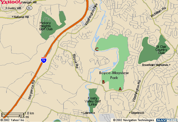
Directions from US Rt. 19 (Washington Road)
Proceed south on US Rt. 19 (Washington Road) to Boyce Road which is 3.0 miles south of South Hills Village Shopping Center (at Ft. Couch Road). Turn right onto Boyce Road and proceed 0.5 miles to the intersection with Morton Road on the right. Turn right and then immediately left into the garden plot parking area (indicated by “A” on the map).
If the gate to the garden plots is closed or as an alternate, continue on Boyce Road another 0.6 miles to the paved turn-off just before Ardolino's Pizza on the right (indicated by “B” on the map).
Another alternate entrance is on Mayview Road. Continue on Boyce Road to the intersection with Mayview Road (next traffic light) and turn right. Proceed 1.1 miles on Mayview Road to the railroad track crossing (indicated by “C” on the map). Park in the small triangle of land on the west side of Mayview Road bordered by the railroad tracks and Chartiers Creek. (There is room for only 2 or 3 cars.) Cross Mayview Road and enter the park through the gate to the wetlands.
Directions from Interstate 79
Take Bridgeville exit (No. 54) from I-79. At the end of the exit ramp, turn right onto Millers Run Road (PA Route 50) and proceed to the traffic light at the T-instersection with Washington Pike in front of the Exxon station. Turn right onto Washington Pike and drive for for 2.1 miles to the intersection with Boyce Road. Turn right onto Boyce and proceed 1.4 miles to the traffic light at the intersection with Mayview Road.
If you want to enter the park through the wetlands, turn left on to Mayview road and drive for 1.1 miles to the railroad track crossing (indicated by “C” on the map). Park in the small triangle of land on the west side of Mayview Road bordered by the railroad tracks and Chartiers Creek. (There is room for only 2 or 3 cars.) Cross Mayview Road and enter the park through the gate to the wetlands.
To use the Boyce Road entrances to the park, continue on Boyce Road for another 0.5 mile to Ardolino's Pizza on the left. There is a paved turn off and parking area just past the pizza shop (indicated by “B” on the map).
You can also use the garden plot parking area at the intersection with Morton Road. Proceed another 0.6 mile to the intersection with Morton Road on the left. Turn left and then another immediate left into the parking area (indicated by “A” on the map).

Click on any of the letters (A, B or C) in the map above to see more detailed maps of those areas. You may also visit Yahoo! Maps for more extensive maps of the area. The Upper St. Clair Township web site has a collection of Boyce-Mayview Park maps including a Boyce-Mayview Property Map.